Maps Formats Available and their Terms and Conditions
The standard Royal Observer Corp (ROC) nuclear monitoring post maps are printed on an U.K. outline map with a grid overlay. This makes it difficult to assimilate the locations of numbered spots with the physical layout of the towns and cities. When the Ordnance Survey made available a free base map, it opened up an opportunity to make a more meaningful map
Over a considerable period of time, I have plotted all the 837 mainland ROC Posts on an Ordnance Survey base map. Unfortunately the lack of a Northern Ireland base map means Belfast No.31 Group is plotted on an outline map only. I am making my efforts available free of charge, so that you may benefit too. In return, I ask that you don't sell my maps or remove the attribution box from the maps.
After plotting so many points, I can't guarantee they are without errors. If you do spot a typo, please get in touch so I may correct it. My contact details are on the Cold War Communications homepage. Use the menubar to Main Site Chapter Index then click the Home Page & Contact Me button.
Maps Available
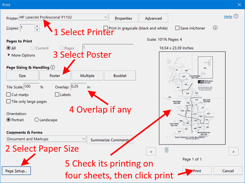
- A4 Single Sheet Group Map, for groups small enough to print on A4
- A4 Multiple Sheet Group Map, for larger groups
- A2 Southern England and Wales, Northern England
- A2 Whole of Scotland
Ordnance Survey Copyright
The OS Terms and Conditions require you agree to display certain text on their maps. I have added this text, but you have to agree not to remove it.
It may seem 'odd' but printing and using a map displaying the Copyright notice is legal, its removal is illegal.
Prepare for Downloading Maps
Please click on the [Make Document Links Ready] button to confirm you are not one of the hundreds of robots trawling the internet for various dubious reasons and wasting website's bandwidth. Right-Click the document link and pick the option to save the document to you computer. Save Link As...

 This page and the maps on it are Copyright © RINGBELL.CO.UK, under a