This top secret facility needed to be at the hub of communications. This topic gives a little insight into how this was kept secret.
Central Government
In the event of a nuclear war, plans were made to disperse national government out of London. During the late Fifties, a former stone quarry near Corsham, Wiltshire that had been used during WWII as an aircraft engine factory, was adapted as the Central Government War Headquarters (CGWHQ). The site, said to measure 700 metres East to West, 275 metres North to South was designed to house 4000 - 5000 people. At a depth of 28 metres below M.O.D. Property, its just South of the Box railway tunnel in a parcel of land bounded by the B3109 Bradford Rd and Westwells Rd in Hawthorn near Corsham.
Passenger Lift PL1
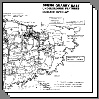
The only publicly visible sign of the CGWHQ is the mould containing the entrance to the passenger lift PL1 viewed from Westwells Road. The layout of the site is shown in the gallery below.
Gallery of CGWHQ Maps
The disused stone quarries all around this area provided the stone for the construction of nearby Bath and many notable buildings throughout the country during the 1800s. See https://en.wikipedia.org/wiki/Bath_stone for more details. Mining began in the Corsham quarries after the thick layer of Bath Stone was discovered during the cutting of the Box railway tunnel in the 1840s. The CGWHQ is just a small part of an extensive stone quarry around the Box area of Corsham, other parts hold the MOD South West Communications Centre and NAVY stores at Copenacre.
Before being declassified in 2004, the site of the CGWHQ was an extremely secret location and protected by various codewords and cover stories about its use. For security purposes the code name of the facility was changed frequently, the approximate periods for these various codewords were : 1951 - 1959 Subterfuge, 1959 - 1961 Stockwell, 1961 - 1963 Burlington, 1963 - 1970 Turnstile, 1970 - 1987 Chanticleer, 1987 - 1992 Peripheral.
This website is concerned with Civilian Emergency War Communications, to obtain an understanding of the policies and politics surrounding its role in a perceived nuclear war, may I suggest reading the e-Book 'TO BURLINGTON AND BEYOND' 'The Story of the Central Government War Headquarters by STEVE FOX' found at URL http://burlingtonandbeyond.co.uk/wp/ not working when checked June 2023, but may be found on the "wayback machine" at URL https://web.archive.org/web/20190930054723/http://burlingtonandbeyond.co.uk/wp/?page_id=11.
$
Communications
The CGWHQ was surrounded by secrecy even though over the years its role was diminishing compared with its original role. Members of the Government who were to take residence were unaware of its location. However communication links were needed for its potential users to keep in touch within the country and abroad. How could these be kept so secret ?
In order that GPO engineers can install and maintain telephone circuits, records need to be kept as to which equipment and external cable pairs are used. All operational buildings are assigned a unique engineering code to distinguish them. These codes are published openly, however codes for military and government establishments are on a need to know basis and kept under lock and key. The CGWHQ was assigned an engineering code, QQCF, within the range used for military and government establishments. So the CGWHQ circuits appeared to be no different from the thousands of other military and government circuits and were lost in the crowd.
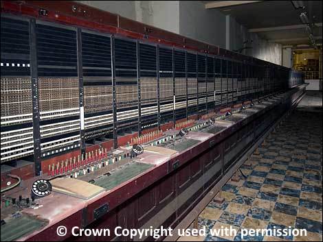
Woodland Switchboard at Corsham
Landlines to GPO / BT Exchanges
CGWHQ internal switchboard known by the name 'Woodland' was connected to a number of Emergency Manual Switching System (EMSS) exchanges. Through the EMSS it was possible to reach all the strategic sites as they were connected to the EMSS. To enable the purpose and location of the CGWHQ to be kept secret, its lines at EMSS switchboards were discretely marked with Private Wire (PW) numbers and nothing else, not even Woodland.
Woodland also had exchange lines connected into the network so they could dial ordinary telephone numbers as long as the public system remained usable in a war situation.
Landlines to Military Locations
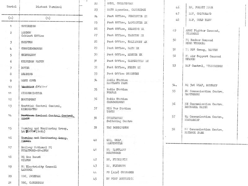
Declassified papers from 1968 show that the CGWHQ, at that time known as TURNSTILE had both speech and teleprinter circuits through the GPO network to military communications centres and other locations. Some would give access to places abroad for diplomatic purposes.
Summary of Turnstile Comms Links in 1968
Future of the Corsham CGWHQ Site
The Central Government War Headquarters is an important site that needs to be preserved for future generations. Ten separate parts of the former CGWHQ are scheduled under the Ancient Monuments and Archaeological Areas Act 1979.
Description
List Entry No.
Radio Studio
1409123
Tunnel Quarry
1409857
GPO Telephone Exchange
1409129
Slope Shaft (Emergency Exit) A
1409125
Personnel Lift (PL) 2
1409130
Quarry Operations Centre (QOC) Murals
1409132
Kitchen, Canteen, Laundry, Dining and Washroom Areas
1409120
Lamson Terminus Room and associated Fan Room
1409121
Prime Minister's Rooms and Operations Rooms
1409131
Quarry Working Areas in West Lung, Spring Quarry
1409858
To see the scheduling visit the Historic England website, ( www.historicengland.org.uk ) and enter the List Entry Number into the search box. Very sadly, many of these scheduled items appear in the 'Heritage At Risk Register', mainly due to the damp atmosphere in the mine.

 This page is Copyright © RINGBELL.CO.UK, under a Creative Commons License details are explained here.