This topic is a simplified description of the defunct MOULD radio system. The original phase provided one system per home defence sub-region and employed 120 hilltop sites. A later contract extended this with the addition of County networks bringing the number of separate networks to ninety and increased the hilltop sites to 150. Based on an article in 'The Wire' circa 1986, by A F Carter with the addition of my own observations.
Overview
MOULD first came to my notice in January 1987 when an article in the RSGB Radcom warned radio amateurs that links between MOULD hilltops were using the 70 cm band that we shared on a secondary basis with the Ministry of Defence (MOD). The article explained that MOULD would provide communications between Regular Army, TA Battalions and the Army District and Regional Headquarters. Phase 1 cost £7m to install and used 18-channel Pye Pegasus radios operating at 66-88MHz. A network of hilltop sites were linked together to give area coverage. These bearer links used 140-150MHz and 420-450MHz in a formation giving a maximum of 7 radio hops between users.
Having been alerted to the presence of the system, I was able to find the frequencies being used locally for the area coverage and the inter site links. I never had the inclination to investigate military communications and back then did not appreciate MOULD's connection with home defence. Only after the scheme closed down has this become apparent, in June 2009 I obtained a copy of a technical article published in the mid-eighties that has filled in the gaps in my knowledge and is the basis for this page. Further information was forthcoming in 2010 and 2011 allowing more specific details to be added.
MOULD closed during the two thousands and the users have been transferred to AirWave the common system for UK Emergency Services' communications used by the Police, Fire and Ambulance authorities. The MOULD equipment was being recovered from hilltop sites during 2008.
The Radio Network
Phase 1 of the UK Army MOULD radio system was introduced in 1976 - 77 in England, Scotland and Wales, but not Northern Ireland, as a communications system was already in place there. It was designed to give area coverage in each home defence region, these align with the civilian Regional Government Headquarters boundaries. In the mid-eighties, Phase 2 provided additional schemes giving area coverage in each county.
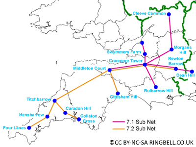
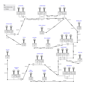
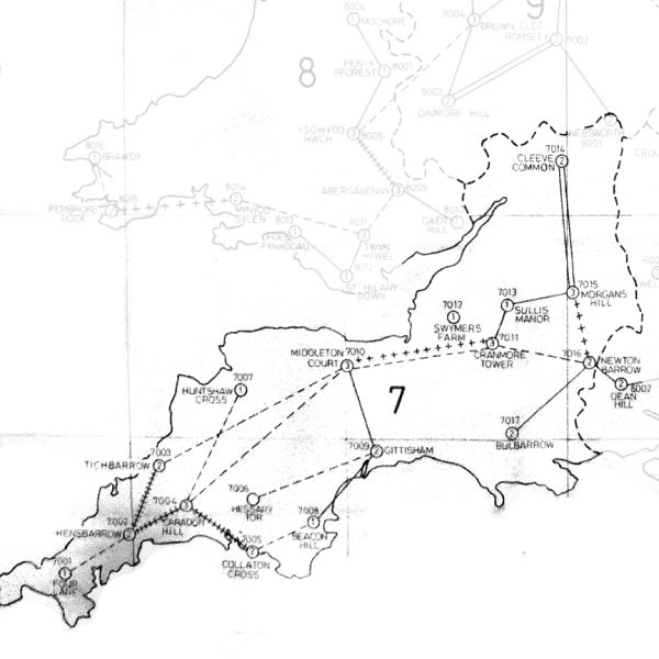
Phase 1 MOULD Network, Region 7
In order to give area coverage a number of hilltop sites with rebroadcasters working in the VHF low band, were connected together with radio links, operating in VHF high band or UHF. In this drawing of the network in Home Defence Region 7, there are two sub networks. In the Sub-Region 7.1 under control of the RGHQ at Chilmark, there are nine hilltop sites, and nine in Sub-Region 7.2 controlled by Bolt Head RGHQ. Three sites Middleton Court, Cranmore Tower and Newton Barrow are common to both networks and have rebroadcasters on both networks. The schemes were carefully designed so there are no more than five links in between any two sites. In Sub Net 7.2 for example, the extremities at Four Lanes or Collaton Cross, are only five links away from Newton Barrow.
Countrywide, Phase 1 employed 120 hilltop sites. This increased to 150 when Phase 2 was implemented.
Most of the English and Welsh hilltop sites chosen for MOULD were those in use by the emergency services and UKWMO / GCN. Some MOD, Civil Aviation and Broadcasting sites were used too. All the hilltop radio equipment was maintained by the No.2 Signals Brigade.
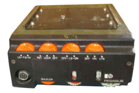
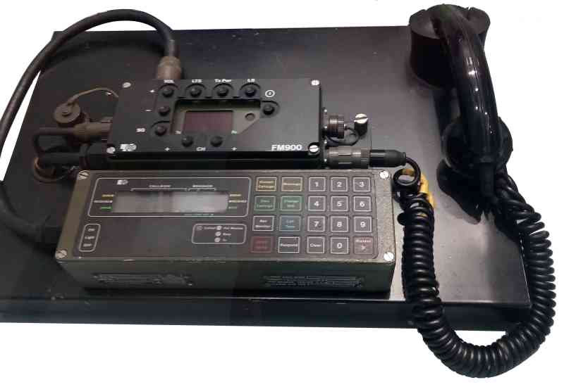
In Phase 1, the MOULD mobile and fixed sets were 18 Channel crystal controlled Pye M252 Pegasus transceivers, outputting 5 to 15 Watts in the 79MHz band and receiving in the 74MHz band. In Phase 2, Pye FM914, 25 Watt synthesized 250 channel transceivers were used.
The hilltop radio equipment was all mains operated. The rebroadcaster equipment was Pye 400 Series, 60 Watt transmitter with a separate receiver, operating in the VHF low band. VHF high band links, using a Pye T404, 25 Watt transmitter and separate R404 receiver. UHF links using a Pye T414, 5 Watt transmitter and separate R414 receiver.
The hilltop rebroadcasters and mobiles, use frequencies in military bands, shared with other fixed and mobile military services. I don't know the exact upper and lower limits of the bands used for the VHF and UHF links, but the approximate band edges are given below.
Mobile Transmit 78.9875-79.9625 MHz and 84.0125-84.8625 MHz
Base Transmit 74.0125-74.7375 MHz and 75.7375-76.5375 MHz
VHF links 141.900-143.000 MHz and 149.000-149.900 MHz
For example, in my notes recorded during an exercise in October 1988, 74.050MHz, 74.125MHz, 74.200MHz, 74.525MHz, hilltop transmit frequencies were all carrying the same traffic. I now find out in 2011 these were four of the five transmitters on the Region 9 Principal Net., which covers the area where I live.
Network Design
The design of the MOULD network is very different from the wide area schemes used by the emergency services. Emergency services have a number of hilltop locations all transmitting and receiving on the same frequency and linked back to a single control point. A full description is given in the 'Emergency Services Radio / Pre 1987' in the website menu. In contrast each of the MOULD hilltop sites use different pairs of transmit (TX) and receive (RX) frequencies to give area coverage. The MOULD network did not have a central control point so adjacent sites were linked together in an open network. A limit of five serial links was imposed to ensure reliable communications.
On any particular network, each hilltop was permitted to have a maximum of five links to other sites. Cranmore Tower, one of the sites shown on the Region 7 map has five links in sub-network 7.1. There are also two links forming part of network 7.2, but this has a separate set of equipment. In Phase 2, and therefore not shown in the drawing above, Cranmore Tower got a third set of equipment working on the Somerset County network.
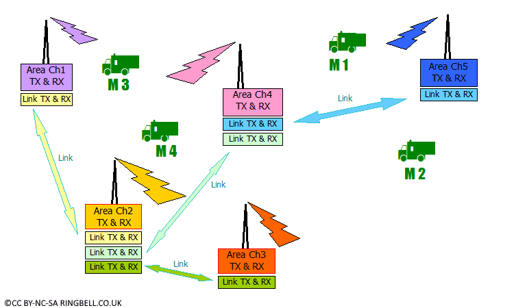
Mobiles accessing MOULD Network
Referring to the diagram above this text, each mobile would select the channel used at the nearest hilltop. For mobiles M1 and M2 this would be Channel 5. If M1 called M2, its signal would be received at the hilltop and be rebroadcast so M2 could hear it. As well as simply rebroadcasting the signal, it would be sent on the link to the next hilltop and broadcast on Channel 4, this site would relay the signal on the link to the next site. Here it would be broadcast on Channel 2, so mobile M4 could hear the signal. This site is linked to two others, where it would be broadcast on Channels 1 and 3. Mobile M3 would also hear the signal on Channel 1. If mobile M3 called mobile M2, it would transmit on Channel 1, its message would be similarly broadcast by all sites on the network, so the other three mobiles including M2 would hear the message as its receiving Channel 5. When M2 replied on channel 5, all the other mobiles including M3 to whom the reply is directed would hear the message.
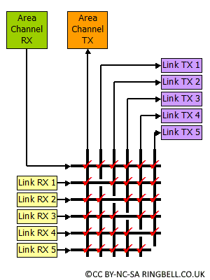
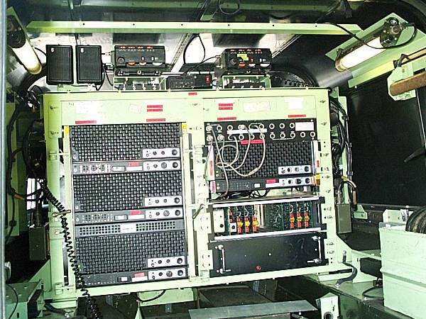
Hilltop Site Control Unit Logic
The hilltop radio equipment was controlled by a 'Control Switching and Signalling Unit' (CSSU). The CSSU routed the signal from the receivers to the appropriate transmitter. The logic diagram shows that any signal received on the low band area channel was rebroadcast by the area channel transmitter and all the link transmitters. A signal received on a particular link would be broadcast by the area channel transmitter and sent out on all the other links except the originating link.
Where two or more networks shared the same hilltop, the CSSU may be configured to link together two networks for operational reasons, usually a 'Principle' Regional Net. and a County Net.
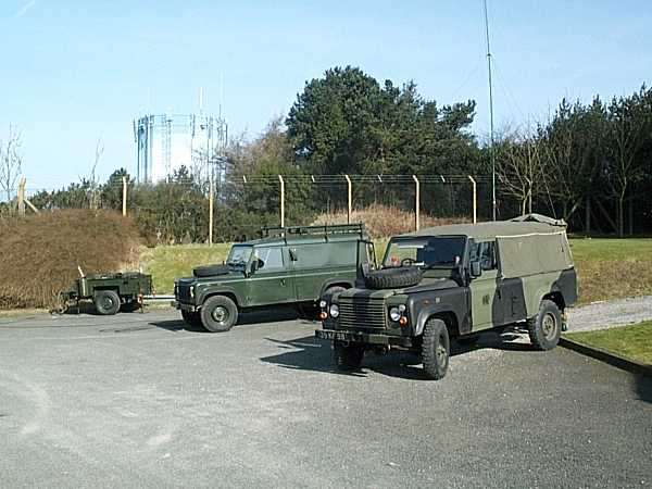
Whereas the emergency services radio schemes had all their transmitters and receivers duplicated, this was not the norm for MOULD, except at the more remote hilltop sites where access could be difficult in adverse weather conditions. To guard against the loss of a hilltop site, due to wartime action or a fault, mobile units known as 'Insertion Vehicles' were kept on standby, so they could be driven to the site to replace it, while repairs were undertaken.
Insertion Vehicle and Support
The 'Insertion Vehicle' is a hardtop Landrover, with a supporting stores vehicle, and a generator. It contains the same equipment used in the hilltop installation. The radios are channelled to allow them to replace any of the MOULD hilltops within the Region it supports.
Radio Installation inside the Insertion Vehicle
Both Vehicle Photographs Courtesy of Martin Swift
MIV Addition Rebroadcaster Allocation
These channels are arranged so the insertion vehicle can act as an additional hilltop site for the mobiles within the region. These channels form part of the Pegasus 18 channels, the remaining channels allow it to replace a non functioning hilltop rebroadcaster.
The insertion vehicle's radio is programmed so its transmitter uses the opposite band to a normal mobile, in this case the lower band (74-75 MHz), whereas normally a mobile would transmit in the upper band. The receive is the opposite way too, listening in the higher band, a normal mobile listens in the lower band.
The final column in the list below shows the Pye 914 radio channel, that normal mobiles would select to use the special rebroadcaster on the insertion vehicle. Listening on the MIV TX and transmitting on the MIV RX frequency.
Region
MIV TX
MIV RX
914 Set Ch. No.
1
74.2125
79.8625
40
1
74.6250
79.9625
238
1
74.0750
79.0125
239
2
74.0375
79.4375
240
2
74.4000
79.8125
241
3 &
74.0875
78.9875
117
3 &
74.3000
79.9125
242
5
76.4750
84.7875
78
5
75.7500
84.3500
243
6
74.4000
79.9125
98
6
74.6250
79.8625
131
6
74.2750
79.8125
244
7
75.8125
84.3875
245
7
76.0875
84.6625
246
8
74.1875
79.0125
134
8
74.4750
79.2375
247
9
74.6250
79.9625
238
9
74.4250
79.8625
248
10
74.2875
79.1375
249
10
74.5125
79.3125
250
MIV Pegasus Allocations in Region 2
These channels are arranged so the insertion vehicle can replace a non functioning hilltop that may have been destroyed by enemy action.
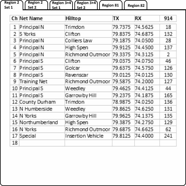
The list identifies the hilltop and the Regional or County Net at that hilltop, that it replaces. The last two channels are additional Regional Channels that are not present at any hilltop. A full list of hilltop channels for Region 2 may be found in the section further down this page Regional Maps and Frequency Data
Region 2; Insertion Vehicle PATTERN ONE Radio
914 Set Ch. No.
Replaces Net / Hilltop Site
MIV TX
MIV RX
1
Humberside / Weedley
74.6250
79.8625
2
Principle N / Trimdon
74.5625
79.7375
3
S Yorks / Clifton
74.6875
79.8375
4
Training / Garrowby Hill
74.3750
79.0875
5
W Yorks / Golcar
74.6375
79.5375
6
Principle N / High Spen
74.450
79.9125
7
Principle S / Richmond Outmoor
74.2000
79.5875
8
Durham / Colliers Law
74.3125
79.6375
9
Principle N / Richmond Outmoor
74.3125
79.3375
10
Northumberland / Ottercops Moss
74.6500
79.1625
11
Principal S / Garrowby Hill
74.1875
79.2375
12
Cleveland / Trimdon
74.6000
79.7875
13
N Yorks / Greenhow Hill
74.6125
79.0675
14
N Yorks / Ravenscar
74.5875
79.6625
15
N Yorks / Garrowby Hill
74.1375
79.9625
16
MIV Rebroadcaster 1
74.0375
79.4375
17
MIV Rebroadcaster 2
74.4000
79.8125
18
Region 2; Insertion Vehicle PATTERN TWO Radio
914 Set Ch. No.
Replaces Net / Hilltop Site
MIV TX
MIV RX
1
Principal S / Clifton
74.0750
79.0375
2
Principal S / Golcar
74.5750
79.6375
3
Principal S / Ravenscar
74.0125
79.0125
4
Principal S / Richmond Outmoor
74.2000
79.5875
5
Principal S / Weedley
74.4125
79.4625
6
Principal S / Garrowby Hill
74.1875
79.2375
7
Humberside / Weedley
74.5000
79.7625
8
Principal N / Trimdon
74.5625
79.7375
9
Principal N / Colliers Law
74.0500
79.1875
10
Northumberland / Brizlee Wood
74.1000
79.2125
11
Northumberland / High Spen
74.2750
79.3875
12
Cleveland / Trimdon
74.6000
79.7875
13
N Yorks / Garrowby Hill
74.1375
79.9625
14
N Yorks / Richmond Outmoor
74.6625
79.6875
15
Durham / Trimdon
74.0250
78.9875
16
MIV Rebroadcaster 1
74.0375
79.4375
17
MIV Rebroadcaster 2
74.4000
79.8125
18
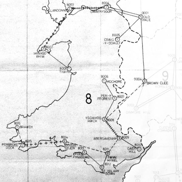
The Full Details - An Example from Region 8
MOULD Region 8 Radio Scheme with Radio Frequencies
In Wales there were two Principal Networks, Region 81 in the North and Region 82 in the South, corresponding with Brackla RGHQ 82 and a nonexistent RGHQ 81. There were eight County Networks in Wales, in Region 81, Clwyd and Gwynedd; in Region 82, Dyfed, Mid, South and West Glamorgan, Gwent and Powys.
The County Networks consisted of one or more hilltop sites, Mid Glamorgan had one rebroadcaster whereas Powys had a network of four. If desired, county networks could be coupled in with the regional Principal Network. Abergavenny was the coupling point for both Gwent and Powys, into Principal for Region 82. Dyfed could be coupled at Mynydd Sylen into Region 82 Principal net. Network control including coupling was performed remotely by the use of SELCALL signals. The hill top site at Old Pale is located in Region 10, but also serves Region 81, with rebroadcasters on networks for Region 10 Principal, Cheshire and Merseyside; Region 81 Principle and Clywd. Similarly Brown Clee is located in the West Midlands Region 9, but also serves Region 81 Principle Net.
18 Channel Mobiles
Channels in a Region 2, Pye M252 Mobile
Pye Pegasus M252
The Pye Pegasus M252 wireless sets used in Phase 1 of MOULD were able to select one of eighteen channels, restricting their use to one defence region. Some regions required two patterns of channel variants. In Region 2, Set No.1 could operate through all nine sites in the 'Principal Net', four on the north and five on the south. A choice of two sites for 'North Yorkshire County Net' but only a single site for the remaining 'County Nets'. Channel 17 is allocated to the Mould Insertion Vehicle (MIV) should it need to be deployed. The Region 2, No.2 type set had a different variation of radio channels, with the emphasis on 'County Nets' as can be seen from the tables below. Some defence regions were divided into two sub-regions aligned with the civilian sub-regional government areas of the RGHQ, an example being Region 8, Wales, divided into subregions 81 & 82.
Click Tabs to see Regional Pegasus Set Allocations
$
The limitation of only 18 channels meant army home defence forces could not be deployed outside their own region. This shortcoming was addressed in Phase 2 by the introduction of sets with 250 channels.
250 Channel Mobiles
The Pye 914 set having 250 channels, was able to cover every network in the whole of England, Scotland and Wales. Northern Ireland was not part of the MOULD scheme. The channel allocations and link maps are shown further down in this chapter, but a complete list is available for downloading.
Pye 914 and Selcall Unit
National List of Sites including TX & RX Frequencies
All these PDF documents are under 40 Kb in size and require the case sensitive password RingBell to open them.
Most of the frequencies were used more than once across the whole country. The separation between sites using the same frequency being sufficient to avoid interference. This series of PDF document lists the Hilltop Transmit Frequency, Receiver Frequency, Channel number for the Pye 914 Radio, Site Name and Network Name in various sorted sequences.
To prevent undesirable indexing of these PDF documents by Web Crawlers, they are encoded, requiring a password to open. I am sorry if this is a nuisance, but html allows whole pages to be excluded from search engine indexes, but not the documents linked from a page.
Regional Maps and Frequency Data
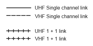
A 'Net' or network consists of one or more hilltop sites all broadcasting the same messages. The map shows the radio links between hilltop sites used to create these networks. Links between hilltop sites were either single channel at VHF or UHF frequencies or two channels per link frequency using a 1 + 1 carrier system with a 'Pye RTU' at each end of the link. VHF links being used across longer hops or difficult terrain where UHF couldn't provide a reliable path. These links are shown on each Regional map according to the Key here. In some places, two separate radio links operating on different frequencies connected hilltops together, these appear as two parallel lines on the map.
A detailed explanation of 1 + 1 speech multiplexing used by MOULD links is provided in a separate chapter on this website. Found in the Miscellaneous Topics part of the Chapter Menu.
Key for Regional Maps
The last two columns give the frequencies that were in use by MOULD rebroadcasters, TX frequency is transmitted from the hilltop and RX is transmitted by the mobile (or fixed mobile stations).
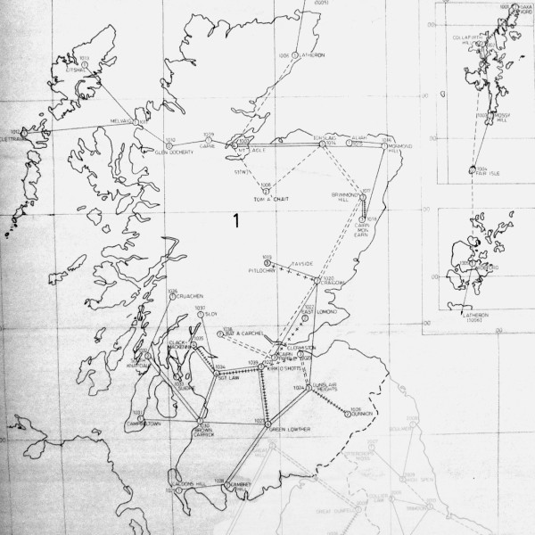
Networks in Region 1 ScotlandCCP Block Schematic
Site
Net
TX
RX
Collafirth Hill
51 North
74.3375
79.5375
Latheron
51 North
74.0125
79.4625
Mossy Hill
51 North
74.0125
79.0625
Mount Eagle
51 North
74.6750
79.6875
Saxa Vord
51 North
74.1500
79.1875
Wideford
51 North
74.0500
79.0375
Bat a Carchel
51 South
74.5125
79.6625
Brimmond Hill
51 South
74.6375
79.7375
Cairn Mon Earn
51 South
76.0125
84.6375
Cairnpapple
51 South
75.7875
84.4625
Craigowl
51 South
76.3250
84.8375
East Lomond
51 South
74.7000
79.6375
Mount Eagle
51 South
74.3000
79.1125
Pitlochry
51 South
74.0250
79.0875
Tom A Chait
51 South
74.1875
79.2375
Torslaisg
51 South
74.5875
79.8875
Garve
51 West
74.2500
79.2875
Melvaig
51 West
74.1000
79.2125
Mount Eagle
51 West
74.7250
79.7875
Tom A Chait
51 West
74.5375
79.0375
Brown Carrick
52 Net
74.4375
79.2000
Cambret Hill
52 Net
74.4625
79.7750
ClachMacKenny
52 Net
74.0375
79.1375
Clermiston
52 Net
74.4000
79.5375
Dunnion Hill
52 Net
74.6875
79.7125
Dunslair Heights
52 Net
74.0250
79.0875
Green Lowther
52 Net
74.1125
79.8000
Kirk O Shotts
52 Net
74.7125
79.7875
Sergeants Law
52 Net
74.2000
79.3125
South Knapdale
52 Net
74.2875
79.0875
Bat a Carchel
Central
74.3125
79.2625
Cairnpapple
Central
75.8625
84.0125
Caldons Hill
DumfriesGalloway
74.1875
79.3875
Cambret Hill
DumfriesGalloway
74.3125
79.7250
Green Lowther
DumfriesGalloway
74.3625
79.8875
Cairnpapple
Fife
76.1625
84.1875
East Lomond
Fife
74.6125
79.5875
Alvah
Grampian
74.3125
79.3875
Brimmond Hill
Grampian
74.5250
79.6125
Cairn Mon Earn
Grampian
75.9125
84.2125
Mormond Hill
Grampian
74.2625
79.2625
Torslaisg
Grampian
74.7000
79.6375
Clermiston
LothianBorders
74.2875
79.2875
Dunnion Hill
LothianBorders
74.1500
79.5875
Dunslair Heights
LothianBorders
74.5375
79.0375
Brown Carrick
North Strathclyde
74.2125
79.6250
Campbeltown
North Strathclyde
74.3000
79.1125
ClachMacKenny
North Strathclyde
74.5500
78.9875
Cruachen
North Strathclyde
74.6125
79.7875
Sergeants Law
North Strathclyde
74.2750
79.8625
Sloy
North Strathclyde
74.3500
79.4625
South Knapdale
North Strathclyde
74.1500
79.5875
Brimmond Hill
Principal Region 1
74.7375
79.3125
Cairn Mon Earn
Principal Region 1
75.7375
84.0875
Clermiston
Principal Region 1
74.2375
79.3375
Craigowl
Principal Region 1
75.9375
84.4375
Dunslair Heights
Principal Region 1
74.1875
79.2375
Green Lowther
Principal Region 1
74.6125
79.8375
Kirk O Shotts
Principal Region 1
74.5875
79.6875
Mount Eagle
Principal Region 1
74.5625
79.5625
Pitlochry
Principal Region 1
74.0875
79.1875
Sergeants Law
Principal Region 1
74.0875
79.0250
Torslaisg
Principal Region 1
74.6500
79.7125
ClachMacKenny
Royal Marines
74.2250
79.5625
Collafirth Hill
Shetland
74.0375
79.8875
Mossy Hill
Shetland
74.4625
79.3875
Saxa Vord
Shetland
74.2375
79.6125
Brown Carrick
South Strathclyde
74.4875
79.6000
ClachMacKenny
South Strathclyde
74.6750
79.8375
Green Lowther
South Strathclyde
74.0625
79.9125
Kirk O Shotts
South Strathclyde
74.2625
79.2125
Sergeants Law
South Strathclyde
74.1625
79.4375
Suidhe
South Strathclyde
74.3375
79.5125
Craigowl
Tayside
75.7500
84.5375
Pitlochry
Tayside
74.6625
79.8875
Clettraval
Western Isles
74.1625
79.4375
Eitshal
Western Isles
74.7375
79.3125
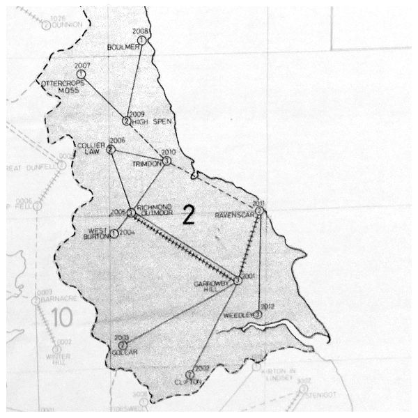
Networks in Region 2 North EastMOULD Region 2
Site
Net
TX
RX
Trimdon
Cleveland
74.6000
79.7875
Colliers Law
Durham
74.3625
79.5375
Trimdon
Durham
74.0250
78.9875
Weedley
North Humberside
74.6250
79.8625
Garrowby Hill
North Yorks
74.1375
79.9625
Greenhow Hill
North Yorks
74.6125
79.0625
Ravenscar
North Yorks
74.5875
79.6625
Richmond Outmoor
North Yorks
74.6625
79.6875
Brizlee Wood
Northumberland
74.1000
79.2125
High Spen
Northumberland
74.2750
79.3875
Ottercops Moss
Northumberland
74.6500
79.1625
Clifton
Principal Region 2
74.0750
79.0375
Colliers Law
Principal Region 2
74.0500
79.1875
Garrowby Hill
Principal Region 2
74.1875
79.2375
Golcar
Principal Region 2
74.5750
79.6375
High Spen
Principal Region 2
74.4500
79.9125
Ravenscar
Principal Region 2
74.0125
79.0125
Richmond Outmoor
Principal Region 2
74.3125
79.3375
Trimdon
Principal Region 2
74.5625
79.7375
Weedley
Principal Region 2
74.4125
79.4625
Weedley
South Humberside
74.5000
79.7625
Clifton
South Yorks
74.6875
79.8375
Garrowby Hill
Training
74.3750
79.0875
Richmond Outmoor
Training
74.2000
79.5875
Golcar
West Yorks
74.6375
79.5375
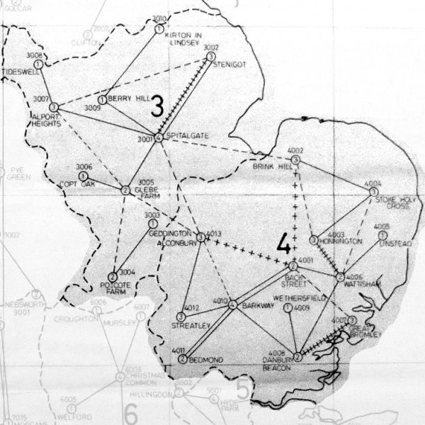
Networks in Region 3 & 4 East Midlands & AngliaMOULD Region 3 + 4
Site
Net
Hilltop TX
Hilltop RX
Streatley
Bedfordshire
74.1250
79.1375
Alconbury
Cambridgeshire
74.0750
79.0375
Barkway
Cambridgeshire
74.2500
79.2875
Alport Heights
Derbyshire
74.2625
79.2625
Tideswell
Derbyshire
74.5625
79.7375
Alconbury
District Command
74.4125
79.4625
Alport Heights
District Command
74.5375
79.6875
Back Street
District Command
74.2625
79.2625
Barkway
District Command
74.1125
79.1125
Brink Hill
District Command
74.3625
79.5375
Glebe Farm
District Command
74.0250
79.0125
Great Bromley
District Command
74.4250
79.4625
Spitalgate
District Command
74.1625
79.1625
Stenigot
District Command
74.2125
79.3125
Stoke Holy Cross
District Command
74.0500
79.1875
Streatley
District Command
74.3250
79.4875
Danbury Beacon
Essex
74.6000
79.7875
Great Bromley
Essex
74.6875
79.6875
Wethersfield
Essex
74.7000
79.4125
Barkway
Hertfordshire
74.5875
79.8875
Bedmond
Hertfordshire
74.2125
79.8625
Copt Oak
Leicestershire
74.5500
79.6125
Glebe Farm
Leicestershire
74.4625
79.4875
Spitalgate
Lincolnshire
74.7125
79.6625
Stenigot
Lincolnshire
74.0375
79.1375
Brink Hill
Norfolk
74.0125
79.0625
Honnington
Norfolk
74.7250
79.8125
Stoke Holy Cross
Norfolk
74.6500
79.7875
Geddington
Northamptonshire
74.3750
79.0875
Potcote
Northamptonshire
74.4375
79.5125
Berry Hill
Nottinghamshire
74.4375
79.5125
Kirton in Lindsey
Nottinghamshire
74.4750
79.4875
Spitalgate
Nottinghamshire
74.4875
79.9625
Barkway
Region 4 Principal B
74.0250
79.0125
Bedmond
Region 4 Principal B
74.4500
79.7375
Danbury Beacon
Region 4 Principal B
74.5000
79.6625
Great Bromley
Region 4 Principal B
74.6250
79.6125
Streatley
Region 4 Principal B
74.5125
79.6375
Alconbury
Regional
74.2000
79.2375
Alport Heights
Regional
74.6500
79.7875
Back Street
Regional
74.1375
79.1375
Brink Hill
Regional
74.7375
79.7625
Glebe Farm
Regional
74.2250
79.2125
Honnington
Regional
74.6375
79.7375
Potcote
Regional
74.6125
79.5875
Spitalgate
Regional
74.3125
79.3375
Stenigot
Regional
74.3875
79.5625
Stoke Holy Cross
Regional
74.1875
79.3875
Wattisham
Regional
74.2875
79.0875
Honnington
Suffolk
74.4375
79.6625
Peasenhall / Linstead
Suffolk
74.2250
79.2125
Wattisham
Suffolk
74.4875
79.9625
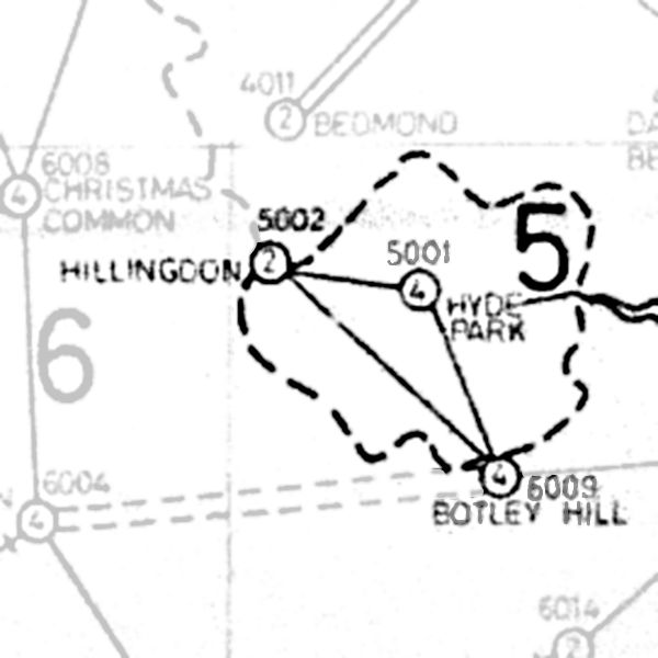
Networks in Region 5 LondonMOULD Region 5
Site
Net
TX
RX
Hyde Park
London North
75.8250
84.1500
Hyde Park
London North East
76.0625
84.2625
Hillingdon
London North West
76.3250
84.8375
Botley Hill
London South East
75.7375
84.0875
Hyde Park
London South West
76.2250
84.3625
Botley Hill
Principal Region 5
76.4375
84.7625
Hillingdon
Principal Region 5
75.8750
84.7125
Hyde Park
Principal Region 5
76.5000
84.8500
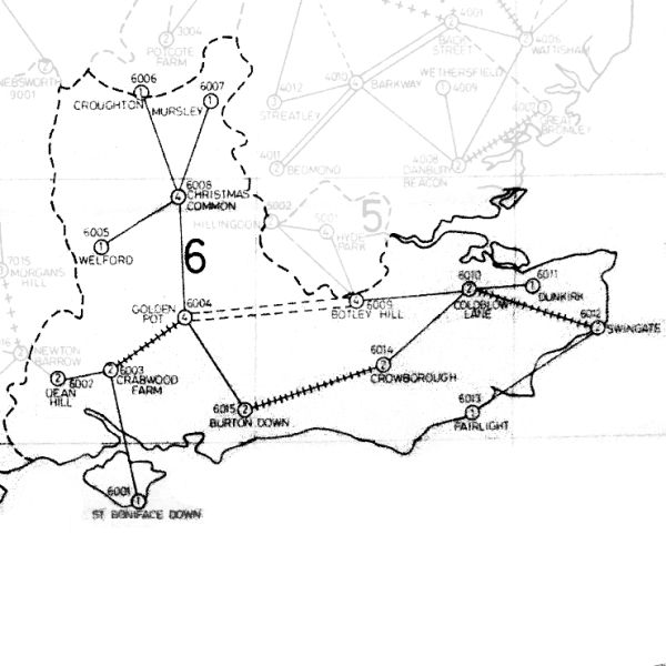
Networks in Region 6 South EastMOULD Region 6
Site
Net
TX
RX
Christmas Common
Berkshire
74.3875
79.4375
Welford
Berkshire
74.6625
79.6875
Christmas Common
Buckinghamshire
74.1500
79.3125
Mursley
Buckinghamshire
74.2375
79.4125
Crabwood Farm
Hampshire
74.6500
79.6125
Dean Hill
Hampshire
74.3625
79.2875
Golden Pot
Hampshire
74.2625
79.2125
St Boniface Down
Hampshire
74.5875
79.6625
Coldblow Lane
Kent
74.5375
79.5125
Dunkirk
Kent
74.6375
79.5875
Fairlight
Kent
74.3500
79.3625
Swingate
Kent
74.2125
79.2375
Christmas Common
Oxfordshire
74.0750
79.1625
Croughton
Oxfordshire
74.1000
79.3625
Botley Hill
Region 6 Principal A
74.0375
79.1875
Burton Down
Region 6 Principal A
74.0500
79.0375
Coldblow Lane
Region 6 Principal A
74.4625
79.3875
Crowborough
Region 6 Principal A
74.5500
79.5625
Golden Pot
Region 6 Principal A
74.0625
79.2625
Swingate
Region 6 Principal A
74.1625
79.1625
Christmas Common
Region 6 Principal B
74.0125
79.0625
Crabwood Farm
Region 6 Principal B
74.4875
79.2375
Golden Pot
Region 6 Principal B
74.0250
79.0125
Botley Hill
Surrey
74.3375
79.3375
Golden Pot
Surrey
74.3125
79.5375
Burton Down
Sussex
74.1250
79.1375
Crowborough
Sussex
74.6750
79.7125
Networks in Region 7 South WestMOULD Region 7
Site
Net
TX
RX
Bulbarrow Hill
71 Net
75.8750
84.5125
Cleeve Common
71 Net
75.7875
84.4625
Cranmore Tower
71 Net
76.4375
84.7625
Middleton Court
71 Net
76.2250
84.3500
Morgans Hill
71 Net
76.3625
84.2875
Newton Barrow
71 Net
75.9375
84.4375
Swymmers Farm
71 Net
75.9125
84.2125
Caradon Hill
72 Net
75.8625
84.3875
Collaton Cross
72 Net
76.3250
84.5750
Cranmore Tower
72 Net
76.3250
84.5750
Gittisham
72 Net
76.0625
84.8625
Hensbarrow Down
72 Net
75.9625
84.2375
Middleton Court
72 Net
75.7500
84.5875
Tichbarrow
72 Net
76.1125
84.0375
Swymmers Farm
Avon
76.5375
84.8500
Caradon Hill
Cornwall
75.9125
84.2125
Four Lanes
Cornwall
75.7500
84.5375
Hensbarrow Down
Cornwall
75.8250
84.1500
Tichbarrow
Cornwall
75.7375
84.0875
Beacon Hill
Devon
76.5000
84.8500
Caradon Hill
Devon
76.3625
84.2625
Collaton Cross
Devon
76.0125
84.6375
Gittisham
Devon
75.7875
84.4625
Huntshaw Cross
Devon
76.4750
84.7875
Bulbarrow Hill
Dorset
76.0750
84.0875
Cleeve Common
Gloucestershire
76.4750
84.7875
Morgans Hill
Gloucestershire
75.8625
84.0125
Cranmore Tower
Somerset
76.1125
84.0375
Middleton Court
Somerset
76.1625
84.1875
Dean Hill
Wiltshire
76.4750
84.7875
Morgans Hill
Wiltshire
75.9625
84.2375
Newton Barrow
Wiltshire
76.0125
84.6375
Networks in Region 8 WalesMOULD Region 8
Site
Net
TX
RX
Gwaenysgor
Clwyd
74.1625
79.3875
Old Pale
Clwyd
74.0625
79.1125
Brawdy
Dyfed
74.3250
79.3375
Mynydd Sylen
Dyfed
74.2000
79.4375
Pembroke Dock
Dyfed
74.6125
79.7875
Abergavenny
Gwent
74.5625
79.5125
Gaer Hill
Gwent
74.3250
79.3375
Llandonna
Gwynedd
74.7375
79.7625
Mynydd Rhiw
Gwynedd
74.4000
79.9125
Tywyn
Gwynedd
74.0375
79.0875
Twyn Hywel
Mid Glamorgan
74.0125
79.8875
Abergavenny
Powys
74.6125
79.7875
Mochdre
Powys
74.2375
79.6125
Pen Y Fforest
Powys
74.6000
79.6375
Ysgwydd Hwch
Powys
74.4500
79.4625
Brown Clee
Principal 81
74.0875
78.9875
Craig-y-Ddualt
Principal 81
74.3375
79.3625
Gwaenysgor
Principal 81
74.0250
79.1625
Llandonna
Principal 81
74.3625
79.4125
Mynydd Rhiw
Principal 81
74.2625
79.2625
Old Pale
Principal 81
74.7250
79.8125
Ysgwydd Hwch
Principal 81
74.1375
79.8125
Abergavenny
Principal 82
74.1125
79.1125
Mynydd Sylen
Principal 82
74.5875
79.6625
Pembroke Dock
Principal 82
74.5625
79.5125
Twyn Hywel
Principal 82
74.3875
79.4125
Ysgwydd Hwch
Principal 82
74.3125
79.2625
St Hilary Down
South Glamorgan
74.6750
79.7125
Twyn Hywel
South Glamorgan
74.7000
79.7625
Foel Fynyddau
West Glamorgan
74.2625
79.3125
Networks in Region 9 MidlandsMOULD Region 9
Site
Net
TX
RX
Dinmoor Hill
HerefordWorcester
74.2250
79.2125
Romsley
HerefordWorcester
74.5750
79.8375
Brown Clee
Principal Region 9
74.2000
79.4375
Dinmoor Hill
Principal Region 9
74.6875
79.7125
Nebsworth
Principal Region 9
74.0500
79.3875
Pye Green
Principal Region 9
74.1250
79.2875
Romsley
Principal Region 9
74.5250
79.3125
Brown Clee
Shropshire
74.0375
79.1375
Pye Green
Staffordshire
74.0125
79.0625
Nebsworth
Warwickshire
74.3500
79.4625
Romsley
West Midlands
74.5000
79.6625
Networks in Region 10 North WestMOULD Region 10
Site
Net
TX
RX
Old Pale
Cheshire
74.3500
79.1875
Great Dun Fell
Cumbria
74.1375
79.9625
Great Hill
Cumbria
74.2500
79.4125
Shap Fell
Cumbria
74.0750
79.0375
Snaefell
Cumbria
74.5375
79.0750
Winter Hill
Greater Manchester
74.6750
79.7125
Snaefell
Isle of Man
74.3875
79.9125
Barnacre
Lancashire
74.2500
79.4125
Winter Hill
Lancashire
74.2125
79.8625
Old Pale
Merseyside
74.5875
79.8875
Barnacre
Principal Region 10
74.7125
79.7875
Great Dun Fell
Principal Region 10
74.2250
79.2875
Great Hill
Principal Region 10
74.0125
79.0625
Old Pale
Principal Region 10
74.1500
79.4625
Shap Fell
Principal Region 10
74.4125
79.4625
Snaefell
Principal Region 10
74.2375
79.5750
Winter Hill
Principal Region 10
74.1125
79.8000
Simplex Operation
Regional channels were allocated for direct vehicle to vehicle operation when they were in range of each other. The set's transmitter and receiver both operate on the same frequency.
Simplex Frequency Allocations
MOBILE TX & RX
914 Set Ch. No.
Region 1
79.7625
232
Region 2
79.2625
233
Region 3 & 4
79.7125
234
Region 6
79.7625
232
Region 8
79.5875
235
Region 9
79.5625
236
Region 10
79.6625
237
Civilian Access to MOULD
The Pye CAT 80 Low Band 80 MHz aerial shown to the right, were used for MOULD as well as commercial Public Mobile Radio (PMR). They were made by Telecommunications Limited (TCL) of Dublin Ireland, which eventually became Sigma prior to its closure, following a buyout of the antenna business of Sigma by American PCTel. TCL / Sigma was a feeder factory for Pye Telecom.
CAT 80 MOULD Aerial
Regional Government Headquarters (RGHQ) had access to MOULD. Local Authority Emergency Control (LAEC) centres had MOULD aerials fitted, either the CAT80 shown here on Dudley Borough LAEC or a folded dipole. The LAEC also had access to the council's own radio scheme, generally used countywide by their highways departments. Post cold war in Cambridgeshire, they tried and tested an interlink between the council's radio scheme and MOULD, allowing direct communication between the two systems. This was demonstrated at a civil protection conference at Scarborough in June 1995.
In the nineties a program of fitting MOULD aerials to civilian buildings was undertaken. Aerials were fitted to larger telephone exchanges and wired down to the protected accommodation in their basement, but no radio equipment was connected. As CAT 80 aerials have been spotted on other public buildings as well as Police and Fire stations, these may have been wired for MOULD too. I can only speculate that this would allow military liaison at those places in a civil emergency.
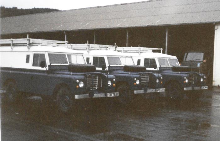
During the eighties a number of local authorities, predominantly Labour Party controlled, declared themselves as 'Nuclear Free Zones'. The Army had some of their MOULD vehicles painted in brighter colours and bore civilian number plates for use in those sensitive local authority areas.

 This page is Copyright © RINGBELL.CO.UK, under a